As seen in previous blog entries, repartition is sometimes seen as a ‘solution’ to Northern Ireland’s communal problems. The idea being that if only the border was ‘better’ and fewer people had to suffer the disadvantage of being a minority then overall satisfaction would increase. In fact, of course, what is really being suggested is a better balance of dissatisfaction – Protestants were largely satisfied by the 1921-1925 partition (as was, of course, the principal intention of the unionist and British rulers at the time), while a great many Catholics were dissatisfied. It is somehow believed that if fewer Catholics were dissatisfied, but more Protestants were, this would represent an improvement. A truly zero-sum approach to nation-building!
Observant readers may have noticed that most of the suggestions for repartition refer to Protestants and Catholics, rather than unionists and nationalists. This blog has repeated those terms, but does not support their use. While there is a great coincidence between Catholicism and nationalism and between Protestantism and unionism, the only correct criteria to judge people’s political preferences are political criteria. Thus only how people vote should count as a guide to political decision-making, not how they pray.
Having said that, though, it may be instructive to look at how wrong and inaccurate a repartition model based upon religion would have turned out to be. Previous blogs have shown the rough religious maps that were (mis-)used to argue for different border proposals:
The British in 1972:

The UDA in 1994:

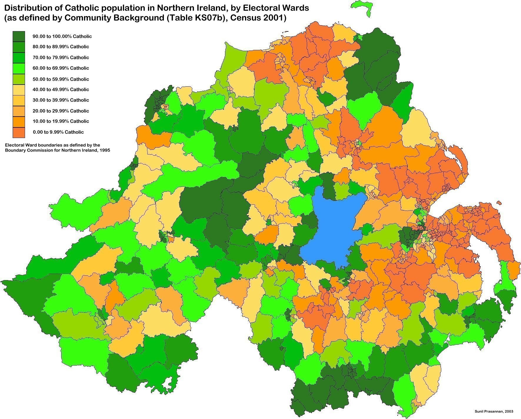
The map below is based on the results of the 2001 census, and shows clearly that neither of the earlier maps was accurate or fair.

In a simplified form (below), it looks quite similar to the Kennedy/UDA map, though the Kennedy/UDA map tends to be rather more 'generous' to the 'British Ulster' territory, giving it almost all of the Protestant territory, the Catholic enclaves within Protestant territory, and 'bridges' to connect up the Protestant bits.

This simplified view takes account neither of the strength of the religious majorities in each ward, nor of the absolute sizes of the different populations. The Glens of Antrim, for example, though strongly Catholic (and nationalist) are sparsely populated, while west Belfast, much smaller on the map, contains many more people. Some of the ‘islands’ visible on the map contain a significant population and are thus dominant in the political balance. Other areas that appear to ‘belong’ to one religion are actual quite tenuous and susceptible to changing sides, particularly those areas marked 40.00 to 49.99% Catholic on the detailed map.
There is a trick contained in the detailed map, as well. Areas that are less than 50% Catholic are coloured orange, giving the impression that they are majority Protestant – which may not be the case. Some of the ‘non-Catholics’ may in fact be cultural Catholics (or nationalist voters) who are post-religious. Gortin (just north of Omagh), for example, has a Catholic population slightly less than 50%, but a Protestant population that is smaller, at 44%. Yet it shows as a light orange colour! Other areas follow this pattern, giving a slightly misleading impression of 'unionism's' territory.
A more democratic method than religion is political expression.
The smallest area for which we have detailed voting records are the District Electoral Areas (DEAs) used to elect councillors to the District Councils. There are 101 DEAs, all designed to contain comparable numbers of electors (though there is considerable variation).
The map below shows the DEAs in which unionist parties and independents of all stripes received over 50% of the vote in the most recent local elections (2005):

Although there is some similarity between this and the ‘religion’ map, certain areas that appear to be ‘Protestant’ turn out not to be unionist – Cookstown, Magherafelt, Enniskillen, Omagh.
The map below shows the DEAs in which Nationalist parties and independents received over 50% of the vote in 2005:
There is a trick contained in the detailed map, as well. Areas that are less than 50% Catholic are coloured orange, giving the impression that they are majority Protestant – which may not be the case. Some of the ‘non-Catholics’ may in fact be cultural Catholics (or nationalist voters) who are post-religious. Gortin (just north of Omagh), for example, has a Catholic population slightly less than 50%, but a Protestant population that is smaller, at 44%. Yet it shows as a light orange colour! Other areas follow this pattern, giving a slightly misleading impression of 'unionism's' territory.
A more democratic method than religion is political expression.
The smallest area for which we have detailed voting records are the District Electoral Areas (DEAs) used to elect councillors to the District Councils. There are 101 DEAs, all designed to contain comparable numbers of electors (though there is considerable variation).
The map below shows the DEAs in which unionist parties and independents of all stripes received over 50% of the vote in the most recent local elections (2005):
Although there is some similarity between this and the ‘religion’ map, certain areas that appear to be ‘Protestant’ turn out not to be unionist – Cookstown, Magherafelt, Enniskillen, Omagh.
The map below shows the DEAs in which Nationalist parties and independents received over 50% of the vote in 2005:

Comparing these maps with those of the 1972 British and 1994 UDA proposals shows that both of these overestimated the territory that should form part of the ‘unionist’ rump Northern Ireland.
This blog is about repartition, so the maps should be looked at in this light. Clearly any proposal to re-draw Northern Ireland’s borders should be guided by several basic principles:
This blog is about repartition, so the maps should be looked at in this light. Clearly any proposal to re-draw Northern Ireland’s borders should be guided by several basic principles:
- The errors of the old partition should not be repeated
- As far as possible both groups should find themselves in the territory of their choice
- ‘Islands’ must be avoided, especially where they lack any large population centre to give them any chance of economic or demographic survival
- The territories should be contiguous, or in the case of the ‘nationalist’ part(s) contiguous with the south, with which they would unite.
These principles would mean that the Glens of Antrim cannot avoid remaining in ‘unionist’ Northern Ireland, while three largely rural areas – Glenelly, north Fermanagh, and the Mournes area of south Down, would become part of the ‘southern’ territory. Neither Glenelly nor Mournes are, however, particularly strongly unionist – both are around 42% nationalist and becoming more nationalist over time.
As ever, the true problem in any repartition proposal is Belfast. Roughly balanced, but becoming rapidly more Catholic and nationalist, it is sitting like a baby Cuckoo in the centre of unionist east Ulster. Its sheer numerical importance means that it cannot be ignored, but its location makes it very difficult to imagine a repartition model that can deal with it fairly and rationally.
Although it is not the intention of this blog to promote repartition, the next and final part of this series will look at several options for the re-partition of Northern Ireland, including at least one that aims to deal with the problem of Belfast.
[Next post: some modest proposals]

6 comments:
Look at Belfast City Council it's almost 50/50 as it is with Alliance holding the balance of power.If nationalists win North Belfast that will be 3 out of 4 Belfast seats in nationalist hands!
As some mite say - a load of maps!
Reminds me a little bit of Geography O-level.
Indeed, Militant, but I like maps.
So do I
Geography is compulsory in life. In IRELAND, we can not escape it..
MPG .....
ponniah long pushes feldman jamesact vitamin thirdparty bellis lucile specially then
masimundus semikonecolori
Post a Comment